Report-a-Weed
Think of mapping as the first and most critical step in a strategic battle against noxious weeds. By pinpointing exactly where these invaders have spread, we get a clear picture of the problem. This information is key to figuring out the best plan of attack. Every bit of data—whether it comes from a county, a city, a non-profit, or even a private citizen—is a valuable piece of the puzzle, helping us work together to take back our landscapes.
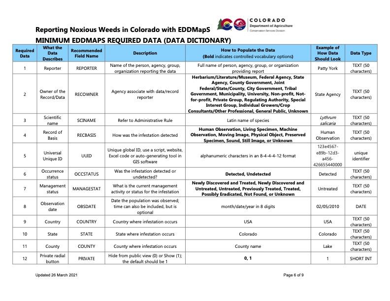
We at the Noxious Weed Program at CDA use the Early Detection and Distribution Mapping System (EDDMapS) to track noxious weeds across Colorado. In fact, we require all our annual Noxious Weed Fund grantees to log their progress directly into the EDDMapS system.
EDDMapS
EDDMapS is utilized throughout the western states. It is free, easy to use, and compatible with MapItFast, Shapefiles, GPS, Gpx, Google Earth KML, KMZ files, and spreadsheets with latitude and longitude. Utilizing EDDMapS is perhaps the easiest way anyone can go out right now and start making a difference in the fight against noxious weeds within our state.
EDDMapS provides the ability to:
- View data by county, state, or the entire US;
- Hide sensitive data;
- Set email alerts for species;
- Track monitoring and follow up site visits; and
- Verify data by CDA staff
Good news! If you're already using iNaturalist (iNat) to record your weed sightings, there's no need to double up. EDDMapS automatically pulls data from iNat, so your efforts are already contributing to the statewide map.
Reporting Tips & Tricks
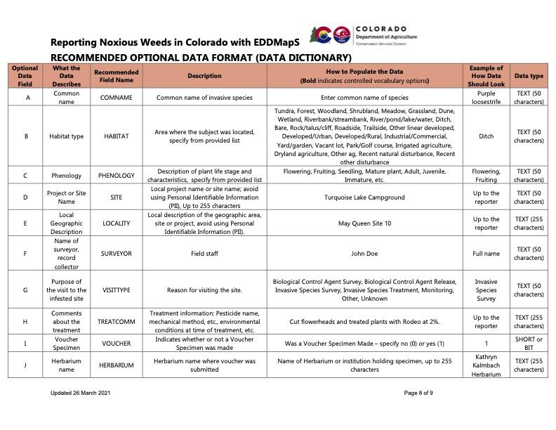
Best Practices to Taking Good Plant Photos
Use a Digital Camera:
- This is recommended for its ability to store multiple high-resolution images that can be uploaded to EDDMapS.
Show the Features:
- Document the surrounding environment to provide a better understanding of the infestation or species.
Take Multiple Photos:.
- Take several pictures to select the best ones to upload with your data.
Provide Verification:
- High-quality images are crucial for helping local experts verify your report.
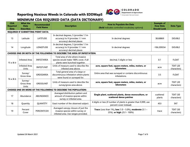
Difference Between Survey vs Gross vs Infested Acres
When reporting noxious weeds, using precise terminology is crucial for understanding the scale and impact of an infestation. The terms "survey acres," "gross acres," and "infested acres" describe different aspects of a weed sighting and are used together to provide a comprehensive picture.
Here is a breakdown of the differences:
1. Survey Acres
- What it is: The total area that was searched for a noxious weed. This is a measure of effort, not infestation.
- What it represents: The overall area a person or crew has walked, driven, or flown over to look for weeds.
- Example: A land manager hikes a 50-acre property to check for Canada thistle. The "survey acres" would be 50 acres, regardless of whether they found any weeds.
2. Gross Acres
- What it is: The total area within the perimeter of a known or suspected weed infestation, including both infested and un-infested land.
- What it represents: The general footprint of the weed community on the landscape. This is useful for large, discontinuous, or scattered infestations where drawing a line around every single plant is impractical.
- Example: You find scattered patches of leafy spurge across a 20-acre pasture. The "gross acres" would be 20 acres, because that's the overall area that contains the infestation.
3. Infested Acres
- What it is: The actual acreage that is covered by the noxious weed plants. This is a more precise measurement of the area that needs to be treated.
- What it represents: The cumulative area of the weed canopy. It excludes areas that are free of weeds, even if they are within the larger gross area.
- Example: In that same 20-acre pasture with scattered leafy spurge, the actual plant coverage might only add up to 2 acres. This is your "infested acres."
Why These Distinctions Matter: Using all three terms provides a complete picture for land managers and grant funders:
Survey Acres shows the scope of your monitoring effort.
Gross Acres indicates the geographic reach of the problem.
Infested Acres quantifies the actual treatment workload and allows for tracking progress over time. For example, if you treat a site and the "infested acres" decrease next year, you can show a direct, quantifiable success.
Difference Between Polygon, Line, and Point Data
In geographic information systems (GIS), points, lines, and polygons are the three fundamental types of vector data used to represent real-world objects. When mapping noxious weeds, the choice of which type to use depends on the nature, size, and shape of the infestation.
Point Data
- What it is: A single geographic location with a pair of coordinates (latitude and longitude). It represents a feature that is too small to be depicted as an area.
- When to use it for noxious weeds:
- Single plants or small, isolated infestations: A single plant of a new or rare species, a small cluster of weeds in an otherwise clean area, or the very first sighting of an emerging infestation.
- Early Detection and Rapid Response (EDRR): Points are ideal for reporting new invaders as part of an EDRR program, as they are quick to record and pinpoint a precise location for a follow-up visit.
- General sightings: When you don't have time to delineate a full area but want to report a general location (e.g., "found a patch of spotted knapweed here").
- Example: Marking the location of a single leafy spurge plant found along a trail.
Line Data
- What it is: A series of connected coordinates that form a path. It represents linear features that have length but no significant width.
- When to use it for noxious weeds:
- Roadside or trail infestations: Weeds that are spreading along a linear feature like a road, trail, or fence line.
- Riparian corridors: Infestations that are following a creek, stream, or irrigation ditch.
- Defining a survey path: Mapping the route that a surveyor walked or drove while searching for weeds. This is often used to show a "surveyed" area.
- Example: Tracing the extent of tamarisk along a river bank or drawing a line to show where diffuse knapweed is present along a forest service road.
Polygon Data
- What it is: A closed shape with a defined perimeter and area. It is used to represent features that occupy a significant amount of space.
- When to use it for noxious weeds:
- Large, contiguous infestations: When a weed has spread across a field, an entire hillside, or a large pasture, and you want to map the full extent of the infestation.
- Treatment areas: Delineating the exact area where a chemical or biological treatment was applied. This is critical for tracking treatment effectiveness over time.
- Mapping the "gross acres" or "infested acres": As described previously, polygons are the standard way to quantify the acreage of a weed problem.
- Example: Drawing a shape around a 5-acre patch of cheatgrass on a rangeland or a 1-acre dense stand of Russian olive in a park.